On Sunday, we drove around the southern part of the island. We intended to drive around the entire island, but between a late start and stopping at as many of the overlooks, historic sites, beaches, and parks as we happened to notice, we were lucky to make it around the southern half in 5 hours. Just driving, it might take 90-120 minutes (the low speed limit of 35 and the windy roads are a big reason, as it isn't that far).
We intend to further explore most of these villages, beaches, parks, and ruins later. For now, pictures! We have added links to some of them for more information, just so you don't have to go to google or wikipedia.
 |
| This beach is where the Marines first landed when they retook Guam from the Japanese in 1944. |
 |
| Fish Eye. It enables you to go into a preserved underwater bomb hole from WW2. |
 |
| Commercial port of Guam |
 |
| Visitors center for the National Park |
 |
| Information on the National Park sites on the island |
 |
| This McDonald's is literally a mobile home |
 |
| Possibly a cane toad? It was a big fella either way. |
 |
| Beautiful mountains of southern Guam. |

 |
| Fouha Point is supposed to be where the goddess who created the world rests, according to Chamorro legend. |
 |
| Cocos Island. Apparently home to a day resort, not unlike Xel-Ha in Mexico. You can take a glass bottom ferry boat from the village of Merizo to the island and spend the day playing in the sun and surf. |
 |
Mountains across the road from the lookout point. There is a trailhead that
starts there for a hike up the mountain. Yay boonie stomping. |
 |
| The viewing platform is literally falling off the mountain. Also, a bunch of trash is stuffed underneath. |
 |
| The Guam Vietnam Veterans Memorial. |
 |
| Many of the men who volunteered to fight weren't even born as American citizens. |
 |
| Helicopter heading back to Big Navy? |
 |
| Supposedly one of the top five most romantic spots on the island, per some online guide. They recommend packing a picnic lunch and enjoying the view. Seems out of place at a war memorial. |
 |
| Magellan landed here. There was a dispute that involed the Chamorro taking a skiff, some violence, and ultimately ended with the Spanish dubbing the Marianas Islands "Islas de los Ladrones", or Islands of Thieves. |
 |
| Magellan Monument. |
 |
An old ruined Spanish church. It was burned down, rebuilt, destroyed in a typhoon, rebuilt,
knocked down in 3 earthquakes and rebuilt each time. Finally, in 1902, a 4th earthquake
knocked it down, and they finally took the hint and left it to nature. |
 |
| You can see the coral used in the building. |
 |
| Umatac Bridge. Not historic, but neat! |
 |
| Concrete igloos? |
 |
| Church and "combento" in Merizo. |
 |
| Plaque written in Chamorro so we didn't understand it (next to the combento). |
 |
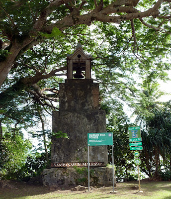
| Ruined bell tower (across the street from the church). |
 |
| Our Lady of Camarin story/legend. |
 |
| Roadside goats! |
 |
| Bear Rock. Nick didn't see it. Looks like a gopher to him. |
 |
| Or a rock subjected to years of erosion. |
 |
Swimming hole in Inarajan (the Salaglula Pool). It is deep enough to allow diving.
The red and white tower on the left is the remaining portion of a diving board. |
 |
There was once a pavilion on the hill on the right, with a bridge and staircase
leading up to it. They were destroyed in a typhoon. |
 |
| Chief Gadao. |
 |
| Inarajan Baptist Church ruins. |
 |
Carabao! (pronounced "Karab-ow") Otherwise known as a water buffalo.
There is a famous dog (who we have met) who wears sunglasses and a straw hat and rides
on the carabao. Look him up. |
 |
| Pretty drive on the southeast side of the island near Talafofo. |


Great pictures! We're waiting for the snakes and spiders, though.
ReplyDeleteOh there are some great pictures here! I love the old ruined churches!
ReplyDeleteGood thing the water buffalo has a saddle, or the dog could fall off!
ReplyDeleteGreat pictures. The pool at Inarajan had a diving board when we were there!
ReplyDelete